

Wanton Bridge is the name tied to one of Rhode Island’s oldest ferry crossings, a narrow stretch of the Sakonnet River between Portsmouth and Tiverton. It began as a ferry landing in the 1600s and later became the site of the Stone Bridge.
In between, storms kept tearing bridges away. Strong currents, coastal gales and finally Hurricane Carol tested every design, and each rebuild tried to be tougher, from timber to stone to steel.
This guide follows the whole story, from Wanton’s Ferry to the fenced-off abutment still standing today, and clears up why the name causes so much confusion. Along the way you will find a dates table and quick answers to the questions people ask most.
Where Was the Wanton Bridge Located?
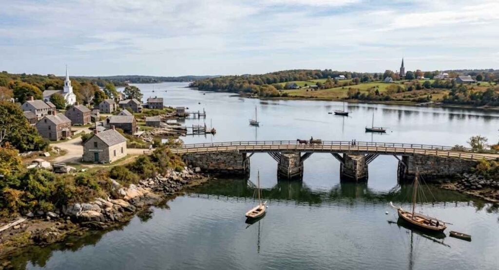
The Wanton Bridge site sits on the Sakonnet River in Rhode Island, where Portsmouth, on Aquidneck Island, faces Tiverton on the mainland side. It was the crossing served by Wanton’s Ferry and later by the Stone Bridge, which carried Route 138 between the two towns.
Ferries here crossed the narrowest part of the river, and the first bridge off Aquidneck Island was built at the same point. A tight channel shortens the trip, but it also brings treacherous currents.
- The current Sakonnet River Bridge stands 0.8 miles north of the old Stone Bridge.
- The old Stone Bridge sits at roughly 41.626° N, 71.217° W.
- Grinnell’s Beach marks the spot where the old crossing landed on the Tiverton shore.
- On the Portsmouth side, what remains of the bridge is used as a fishing pier.
| Detail | Answer |
|---|---|
| River | Sakonnet River |
| Towns connected | Portsmouth (Aquidneck Island) and Tiverton |
| Later name of the crossing | Stone Bridge |
| Road it carried | Rhode Island Route 138 |
| Distance from today’s bridge | About 0.8 miles south |
| Approximate coordinates | 41.626° N, 71.217° W |
Wanton’s Ferry Before the Bridge
Before any bridge, people crossed by boat. A ferry between Portsmouth and Tiverton, probably the first regular ferry in Rhode Island, began operating in 1640. Not every account agrees on the start date, and one local history places the ferry from the 1680s.
The ferry moved goods, horses, wagons and people across the Sakonnet River. During the Battle of Rhode Island, American forces used the landing to reach Aquidneck Island, and many used it again to retreat. That made the ferry landing behind the Wanton Bridge crossing more than a local convenience.
| Name | Connection |
|---|---|
| Howland’s Ferry | Named for the family that ran it from about 1703 to 1776 |
| Pocasset Ferry | Alternate name for the same crossing |
| Sanford’s Ferry | Linked to John Sanford, who took over the ferry |
| Wanton’s Ferry | Alternate name for the same crossing |
| Anthony’s Ferry | Another name found in local records |
How the First Bridge Changed Travel
In 1795 the Rhode Island Bridge Company built a private toll bridge near the ferry. Its designer was Zenas Whiting of Norwich, Connecticut, and the bridge, about 900 feet long, was built of stone and timber. Travelers now paid a toll and walked, rode or drove across without waiting for a boat.
The local paper welcomed it in October 1795 as a link between the island and the mainland at Tiverton. For the first time, Aquidneck Island had a fixed road connection on this side.
The gain did not last. A high tide swept the first bridge away within two years, the rebuilt bridge lasted about a year, and the ferry returned for roughly a decade.
Storm Damage at the Crossing
The narrow channel that made this a good place to cross also made it a hard place to keep a bridge standing. The bridge was washed out or damaged at least a dozen times before its final replacement. Storms were not the only threat, since ships also rammed the structure.
| Period | What happened |
|---|---|
| Within two years of 1795 | First bridge swept away by a high tide |
| 1798 to 1808 | Bridge rebuilt in 1798, then out of use until 1808 |
| 1815 | The Great Gale of September 1815 tore out a 200-foot section |
| Late 1860s | A gale breached the bridge and the draw section washed away |
| 1871 | Tiverton and Portsmouth bought the bridge and passed it to the state |
The state then reopened the bridge as a free crossing without a toll.
Stone Causeway and Draw Span
After repeated storm losses, a stone causeway with a wooden draw span was built in 1810. Stone was a sturdier answer to a river that kept breaking timber. Local histories put the cost at well over $200,000, funded by subscribers.
The draw span mattered as much as the stone. A movable section opened the channel so boats could pass while wagons used the rest of the roadway. Newspaper accounts from the 1840s mention Gideon Manchester, a Tiverton man who tended the drawbridge.
- Stone causeway built across the shallows
- Wooden draw span for vessels
- The Stone Bridge name took hold after the 1815 gale, when the bridge was rebuilt
The 1907 Stone Bridge

The Newport Street Railway opened in 1898, linking Newport and Fall River, Massachusetts. Its heavy streetcars made the wooden draw span unworkable, so it had to be replaced.
The answer, opened in 1907, was a double-leaf steel rolling lift bridge, a type of bascule bridge. Its two leaves lifted to clear the channel for boats. The bridge was the key link between Fall River and points north and Newport and points south.
| Period | Structure | Material | Notes |
|---|---|---|---|
| 1795 | Wooden toll bridge | Timber | Swept away within two years |
| 1810 | Stone causeway with wooden draw span | Stone and timber | Damaged in the 1815 and 1860s gales |
| 1907 | Steel double-leaf rolling lift bridge | Steel | Built for streetcar weight, carried Route 138 |
Hurricane Carol and the Old Stone Bridge
Hurricane Carol severely damaged the bridge in 1954, and it was closed to marine traffic afterward. For the Wanton Bridge crossing, Carol was the storm that began the end of its life as a road. The new Sakonnet River Bridge, 0.8 miles north, was already under construction.
| Date | Event |
|---|---|
| 1954 | Hurricane Carol severely damages the bridge |
| January 13, 1955 | Closed to buses and trucks |
| January 18, 1955 | Closed to all vehicles, with pedestrians still allowed across |
| March 3, 1955 | Reopened to all traffic after repairs |
| 1956 | Remained in service until the Sakonnet River Bridge opened |
Some local sources date the replacement to 1957. While the bridge was out, ferries such as the West Side filled the gap. The remaining approaches now serve as breakwaters and fishing piers.
Wanton Family Connection
Wanton’s Ferry is one of the recorded names for the Portsmouth to Tiverton ferry, alongside Howland’s, Pocasset and Sanford’s. Published accounts that list these names do not explain how the Wanton name became attached.
The operator record points to other families, since the Howlands ran the ferry from about 1703 to 1776.
The Wantons were still a major presence nearby. Four descendants of Edward Wanton served as governor of colonial Rhode Island between 1732 and 1775.
Joseph Wanton moved to Tiverton in 1688 to work as a shipbuilder, and his son Gideon, born in Tiverton in 1693, later became governor.
That local prominence may help explain why the name stuck, but the records do not confirm it.
| Name | Link to the crossing |
|---|---|
| Howland | Ran the ferry from about 1703 to 1776 |
| Sanford | Early ferry operator |
| Wanton | Prominent Tiverton and Newport family, recorded as an alternate ferry name |
Why the Name Wanton Bridge Can Cause Confusion
Accounts of this crossing speak of Wanton’s Ferry and, later, the Stone Bridge. The phrase Wanton Bridge blends the two, which is why it floats without a clear home.
The Wanton link is real but early. A William Wanton received the ferry property in 1687, more than a century before the first bridge.
| Name | What it refers to |
|---|---|
| Wanton’s Ferry | Early ferry name, tied to William Wanton’s ownership from 1687 |
| Howland’s Ferry | The best-known ferry name, used from about 1703 to 1776 |
| Stone Bridge | The bridge at the same site, named after the rebuild that followed the 1815 gale |
| Sakonnet River Bridge | The modern Route 24 and 138 bridge, 0.8 miles north |
| Sakonnet River rail bridge | A nearby 1899 swing bridge, removed in 2006 and 2007 |
| Wanton Bridge (novel) | A 1989 romance by Rosalyn Alsobrook, sometimes listed as Wanton Bride |
| Wanton Shipyard | A separate historic site on the North River in Massachusetts |
Transportation and Local Trade
For generations, this crossing worked like a funnel. Foot, horse and wagon traffic, and later cars and streetcars, all had to pass through it.
Ferry and bridge alike carried goods, horses and wagons. A toll keeper collected fares at the bridge.
Local life bent around it:
- East Main Road in Portsmouth was once known as the Path to Howland’s Ferry.
- Tavern keepers, innkeepers and ferry operators along the approaches depended on travelers.
- The bridge charged tolls until 1871, when it became a free crossing.
Wanton Bridge and Maritime Traffic
The Sakonnet River is a navigable channel about 14 miles long, running from Mount Hope Bay to Rhode Island Sound. Any bridge across it had to leave room for boats.
That is why the 1810 bridge had a wooden draw span and the 1907 bridge a steel double-leaf lift. Ships still rammed it at times.
| Period | How boats passed |
|---|---|
| 1810 to 1907 | Wooden draw span, worked by a drawbridge keeper |
| 1907 to 1954 | Double-leaf steel rolling lift span |
| After 1954 | Closed to marine traffic |
| Since 1956 | Fixed bridges to the north, the current one with about 100 feet of clearance |
Wanton Bridge and Regional Transportation
The Stone Bridge sat on the key route linking Fall River and Newport. It carried Route 138, and streetcars from 1898.
Until the Mount Hope Bridge opened in 1929, it was reportedly the island’s only bridge. The Sakonnet River Bridge that replaced it was rebuilt in 2012 for $120 million.
| Crossing | Built | Status |
|---|---|---|
| Ferry (Wanton’s, then Howland’s) | 1640 | Gave way to the bridge in the 1790s and returned whenever the bridge failed |
| Stone Bridge | 1795, 1810, 1907 | Closed to traffic in 1956, approaches remain |
| Sakonnet River rail bridge | 1899 | Closed 1988, removed 2006 to 2007 |
| Sakonnet River Bridge (truss) | 1956 | Demolished in 2012 |
| Sakonnet River Bridge (current) | 2012 | Four lanes, about 40,000 vehicles a day, no toll |
What Happened to Wanton Bridge?
Hurricane Carol crippled the 1907 Stone Bridge in 1954, and the Sakonnet River Bridge replaced it in 1956. The center span was later removed, leaving only the approaches.
That ending followed a long pattern. Eight bridges have linked Tiverton and Portsmouth here since 1795, and the Stone Bridge was washed out or damaged at least a dozen times.
- 1954: Hurricane Carol severely damages the steel bridge
- 1956: The Sakonnet River Bridge opens 0.8 miles north
- Later: The center span is removed
- Today: The approaches remain as breakwaters and fishing piers
Wanton Bridge Today
The crossing now survives as two remnants facing each other across the water. Tiverton’s side is a park and pier, while Portsmouth’s abutment is fenced off.
Tiverton bought its section in 2014 and had turned it into a paved pier beside Grinnell’s Beach by 2019. Anglers fish there for tautog, striped bass and scup.
In Portsmouth, part of the abutment collapsed in 2019. The state spent $850,000 on a rock wall and closed it to the public.
| Side | What is there | Public access |
|---|---|---|
| Tiverton | Grinnell’s Beach, paved pier, park and bathhouse | Open, with seasonal beach rules |
| Portsmouth | Teddy’s Beach and the fenced abutment | Abutment closed, restoration still sought as of early 2024 |
Wanton Bridge Historical Dates
| Year | Event |
|---|---|
| 1640 | Ferry service begins between Portsmouth and Tiverton |
| 1687 | Ferry property deeded to William Wanton |
| 1703 to 1704 | Property sold to Daniel Howland of Tiverton |
| 1795 | Wooden toll bridge built by the Rhode Island Bridge Company |
| 1796 to 1797 | First bridge washed away |
| 1798 | Rebuilt bridge fails, crossing closed until 1808 |
| 1810 | Stone causeway with wooden draw span opens |
| 1815 | Great September Gale damages the bridge |
| 1868 to 1869 | Gale breaches the bridge, draw section washes away |
| 1871 | Towns buy the bridge and pass it to the state as a free crossing |
| 1898 | Newport Street Railway opens |
| 1907 | Steel double-leaf rolling lift bridge opens |
| 1954 | Hurricane Carol severely damages the bridge |
| 1955 | Closed in January, reopened March 3 |
| 1956 | Sakonnet River Bridge opens |
| 2012 | New Sakonnet River Bridge opens |
| 2014 | Tiverton buys its abutment |
| 2019 | Tiverton pier completed, Portsmouth abutment partly collapses |
Accounts disagree on three points: whether the ferry began in 1640 or the 1680s, whether the first bridge fell in 1796 or 1797, and whether the Sakonnet River Bridge opened in 1956 or 1957.
Frequently Asked Questions About Wanton Bridge
Where was Wanton Bridge located?
On the Sakonnet River between Portsmouth and Tiverton, Rhode Island. The site lies about 0.8 miles south of the current Sakonnet River Bridge.
Is Wanton Bridge the same as the Stone Bridge?
The name points to the same crossing. Wanton’s Ferry ran there first, and the Stone Bridge was built on the site later.
Was Wanton Bridge a ferry?
No, but Wanton’s Ferry crossed at the same spot before any bridge. The ferry also went by the names Howland’s, Pocasset and Sanford’s.
What replaced Wanton Bridge?
The Sakonnet River Bridge, opened in 1956 about 0.8 miles north. It was replaced again in 2012.
Why did the crossing have a draw span?
Boats needed to pass along the Sakonnet River. The movable section opened the channel while the roadway carried traffic.
Why did the bridge keep failing?
Strong currents, coastal storms, ship collisions and heavier traffic wore down each version.
Who was Wanton in Wanton’s Ferry?
A William Wanton received the ferry property in 1687. It was sold to Daniel Howland of Tiverton around 1703.
Can you visit the old crossing today?
Yes, on the Tiverton side, where a pier and Grinnell’s Beach sit at the old landing. The Portsmouth abutment is closed.
A Closer Look: Why This Crossing Kept Failing
The geography that made this a good place to cross also made it hard on bridges.
Narrow water, treacherous currents and open exposure to coastal storms tested every design.
| Factor | Effect |
|---|---|
| Currents | Treacherous water around the site, with the first bridge swept away by a high tide within two years |
| Storms | The 1815 gale tore out about 200 feet, a late 1860s gale breached the bridge, and Carol struck in 1954 |
| Vessels | Ships rammed the bridge |
| Heavier loads | Streetcars from 1898 outgrew the wooden draw span |
| Repeated damage | Washed out or damaged at least a dozen times |
Each rebuild answered the last failure, with timber giving way to stone and stone to steel. The Wanton Bridge crossing lasted until Carol finally ended its run.
Final Thoughts
Wanton Bridge is best read as one name for a crossing with several lives. It was a ferry landing, then the Howland ferry, then a string of bridges known as the Stone Bridge.
What lasted was not a single structure but a place, a narrow stretch of the Sakonnet River that tied Portsmouth to Tiverton for generations.
Today, visitors can still stand at the old landing on the Tiverton shore and see the water that shaped the whole story.

AtlasWorth Editorial publishes well-researched content on celebrity net worth, biographies, entrepreneurs, and business leaders. Our articles are based on publicly available information from reliable sources and are regularly reviewed for accuracy and relevance.